
WELCOME TO SCANSURE
Rethink Your Next Building Survey
When renovating an existing building, one of the first steps towards a successful project is conducting a building survey to generate existing background drawings. Scansure is a 3D Laser Mapping service that bridges the gap between slow and tedious hand surveying, and the well known, expensive terrestrial scanners that are also slow and tedious. We do this by using hand-held, mobile laser scanners that continuously capture 3D spatial data while simultaneously mapping their environment using robotics algorithms. The result is a much faster, yet reliable building survey that provides you with a permanent point cloud reference, available for faster project delivery. With this low-cost service, nearly every project can now benefit from the value of having a permanent 3D reference that increases the efficiency of every design team.
ABOUT SCANSURE
A Dream Realized
Over the years in his architecture career, Scansure's founder, Douglas Magners, spent many long days on sites documenting a variety of existing buildings for renovation projects. Most days concluded with the same frustrated thought, "There must be a better way!"
Although terrestrial 3D laser scanners had been around, they were often too cost prohibitive for most projects, and still involved an immense amount of time and labor. These scanners were reserved for only the most demanding projects with a large budget.
However, with the emergence of mobile 3D laser scanners, Douglas immediately recognized the value that this technology offered other designers: affordable 3D documentation that took far less time and money!
Finally, an alternative solution existed that could drastically cut down on time wasted in the field, provide a 3D, full-scale digital reference for generating drawings, and at a price that made it practical for virtually every project. Thus, Scansure was born.

Interior of Old North Church

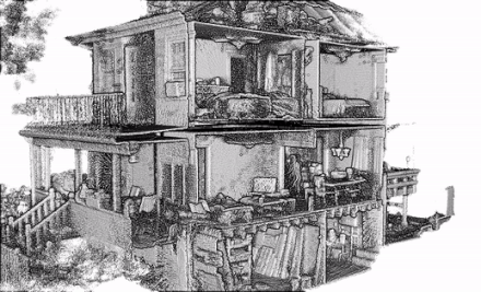
Plan View of Scansure Point Cloud

Scansure Point Cloud showing the plenum space for determining the highest ceiling elevation

THE ORIGINS
The Frustration of Building Documentation
A successful renovation of an existing building starts with having base background drawings of the building. Occasionally, the building owner might have a copy of the original drawings from when the building was constructed, however, these are rarely very accurate, either because of deviations during construction, or modifications to the building over time. Of course it is also very common that the original drawings have been lost over the years. Thus, most renovation projects involve a very arduous process of hand measuring the building with tape measures and laser range finders. After many long hours, if not days, of making hand sketches and trying to measure every feature in the building, the design team then has to start from scratch and convert those notes into a CAD drawing or BIM model. THEN the design process can begin!

HOW TECHNOLOGY ANSWERED THE CALL
The Early Days of Laser Scanners
Eventually, technology caught up, and 3D laser scanner stations were introduced to the process. 3D scanners work like the laser range finders many architects already use, except these devices take thousands of measurements per second while spinning 360°. The result is a "point cloud" of millions of points in space that represent the actual building, which can now be used as a reference for drafting.
While these scanners have many benefits for certain situations, they also have some significant downsides: they are rather expensive as well as require a great deal of time and labor to set up each individual scan and stitch all the scans together.
THE SCANSURE DIFFERENCE
Scansure now offers architects and designers an alternative solution that saves time, money, and the frustration of manual building surveys without blowing the budget on terrestrial scanners.
The mobile scanner works simply while you walk through and around the building, automatically generating a registered point cloud using the features of the building as its targets. This means less time setting up individual shots with targets, less time on registration, and lower costs.
Upon completion of the scans, the point clouds undergo a quality control check, then are converted to the file type required for your typical drafting / BIM programs, and delivered to the designers. From there, it is a matter of simply inserting the point cloud (much like inserting a PDF), and you can now start drafting or modeling right over the point cloud!

REQUEST MORE INFO
Schedule a demo for your office, request a sample, request the Estimate Calculator,
or book your first Scansure scan.
Mailing Address:
288 Grove St #216, Braintree, MA 02184, USA
Email:
Phone:
(617) 934-6124